|
|
Challenging the Wisdom of the Trans Texas Corridor.
|

| Trans Texas Corridor | |||
|---|---|---|---|
|
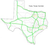
TTC-35 Recommended Preferred Corridor Alternative (April 2006) |
What Is The Trans Texas Corridor? The Trans Texas Corridor
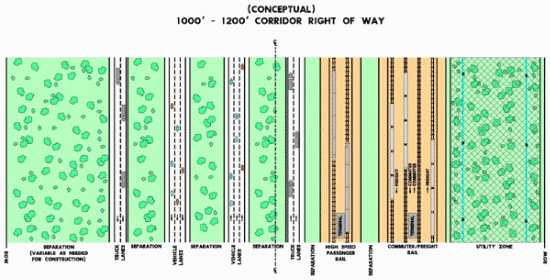
is not a toll road, The Trans Texas Corridor (TTC) is not one but several all-Texas 1/4-mile-wide corridors that are planned to include toll roads for passenger vehicles and trucks, passenger bullet trains, commuters trains, high-speed freight trains, pipelines of all types, and electrical transmission towers. Plans also include gas stations, garages, restaurants, hotels, stores, billboards, warehouses, freight interchange, intermodal transfer areas, passenger train stations, bus stations, parking facilities, dispatch control centers, maintenance facilities, pipeline pumping stations, and of course, toll facilities.
The Trans Texas Corridor is the largest engineering project ever proposed for Texas. The corridor will far exceed any public works project in the state’s history. This statewide network of priority corridors will stretch 4,000 miles and measure up to 1,200 feet wide. Each segment of the corridor will contain:
Four priority corridors have been identified. Those corridors parallel:
I-69 (proposed) from Texarkana to Houston to Laredo. I-45 from Dallas-Fort Worth to Houston. I-10 from El Paso to Orange. The priority corridors account for about half the total 8,000 miles of the Trans Texas Corridor. In addition to TxDOT, private-sector analysis will identify other corridors for immediate development and future investment. TxDOT or the private sector will develop the other corridors as each segment becomes more necessary. The typical corridor section will require 146 acres of right of way per mile. The total anticipated right of way for 4,000 miles of priority corridor is 584,000 acres. Based on an estimated cost of $31.4 million per centerline mile, the 4,000-mile corridor will cost $125.5 billion, not including right of way and miscellaneous costs. Factoring in right of way at $11.7 billion to $38 billion and miscellaneous costs at $8 billion to $20 billion, the estimated total cost for the Trans Texas Corridor ranges from $145.2 billion to $183.5 billion.
No major land acquisition in metropolitan areas is required. The TxDOT plan states that they need to move quickly in developing the corridor segments that will generate the highest toll level—revenue that will enable them to extend the corridor into every section of the state. The vision is that the corridor will be developed in phases through several scenarios. For example, the heavy-duty truck lanes (two in each direction) could be built first, to be shared initially by both passenger vehicles and trucks. As traffic volumes increase and additional capacity is warranted, separate passenger lanes will be constructed. The rail component also lends itself to phased construction. Construction of high-speed passenger rail to connect the largest population areas will be implemented as the need grows for travel alternatives. The TxDOT plan anticipates that they would lease undeveloped segments of the corridor back to adjacent landowners. Connection between the corridor and nearby cities will be accomplished with the existing highway system. Proposed corridor segments will require interconnection with additional modes of transportation to enable passengers and freight to reach their final destinations in nearby cities. Privately funded franchises or public-private partnerships will provide transportation from the corridor to destination cities. These corridor connections will create investment opportunities for public-private partnerships, utility companies and privately funded franchises interested in providing utility lines, intermodal freight transfer facilities and passenger facilities at strategically located access points. All roadways (excluding unpaved county roads), rails and streams intersecting the corridor are assumed to be grade-separated. Most crossings will be handled by simple grade-separation bridge structures. These allow existing local highway and rail facilities to cross the corridor but not access it. Grade separations may be provided for farm to market highways, two-lane state highways, rail lines and paved county roads. The corridor may cut through about 1,200 unpaved county roads. These roads will be reconnected to other facilities to maintain efficient traffic flow. TxDOT will endeavor to assist counties in rebuilding any important intra-county routes affected by the corridor. Double-diamond interchanges will be used where the corridor intersects a highway serving a significant regional traffic base. These interchanges will provide access to and from the corridor and the crossing facility. Double-diamond interchanges will be necessary for about 60 percent of all state highways and 80 percent of all U.S. highways intersecting the corridor. [Law adopted in 2005 expanded the connectivity to include all state and U.S. highways intersecting the corridors.] Directional interchanges will be used where a corridor segment intersects a major highway serving cross-state traffic. Much of the traffic from both the corridor and crossed highway facilities will need an interchange between these intersecting routes. Direct-connection interchanges will be provided at all 23 locations where the corridor intersects itself, at all interstate highways intersecting the corridor and U.S. highways. |
||
This Page Last Updated: Thursday March 08, 2007