|
|
|
This is the official Texas Department of Transportation Trans-Texas Corridor Plan, adopted June 2002
Crossroads of the Americas: |
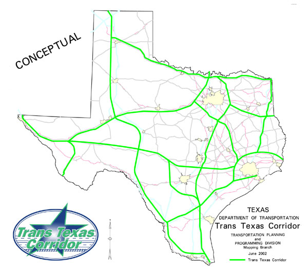
The Trans Texas Corridor is envisioned as a network of transportation corridors up to 1,200 feet wide. The statewide corridor will include separated lanes for passenger vehicles and trucks, high-speed passenger rail, high-speed freight rail, commuter rail and a dedicated utility zone. Figure 1
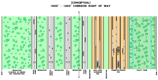
The concept includes separate lanes for passenger vehicles (three lanes in each direction) and trucks (two lanes in each direction). The corridor also will include six rail lines (three in each direction): two tracks for high-speed passenger rail, two for commuter rail and two for freight. The third component of the corridor would be a protected network of safe and reliable utility lines for water, petroleum, natural gas, electricity and data. (Figure 2). Issues to be addressed in the planning process include assessing the impact on currently planned construction projects, determining facilities needed to connect the corridor segments to nearby cities, connectivity to facilities in Mexico and adjacent states, public involvement, and route analysis and selection.
Impact on currently planned construction projects Corridor construction could affect more than $2 billion in planned statewide mobility projects. Projects along existing major highways paralleling proposed corridor routes may not require as much right of way, could be modified in scope or even delayed. Not included in this estimate are projects the commission has previously funded. Most Phase 1, Priority 1 Trunk System projects will continue to be developed. Facilities needed to connect the corridor to nearby cities Connection between the corridor segments and nearby cities can be accomplished by using the existing highway system. Proposed corridor routes will require interconnection with additional modes of transportation to enable passengers and freight to reach their final destinations in nearby cities. Privately funded franchises or public-private partnerships will provide transportation from the corridor to destination cities. Though not an exhaustive list, the following most likely would be developed:
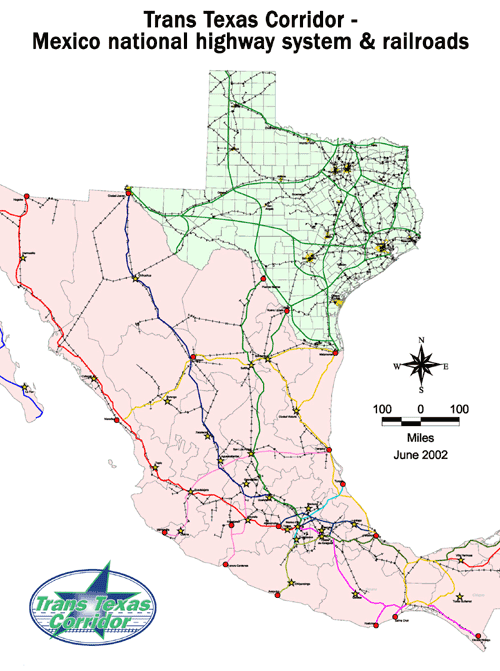
Light rail: Passenger train service using modern day trolley or updated streetcar technology. Electric trains travel on rails within existing railroad rights of way, dedicated right of way, or along right of way also used by vehicles. Commuter rail: Passenger train service for short distance travel between a central city such as Dallas and its suburbs, or longer distance travel between cities such as Austin to San Antonio. Trains can be pulled by a diesel locomotive or be self-propelled. These corridor connections will create investment opportunities for public-private partnerships, utility companies and privately funded franchises interested in providing utility lines, intermodal freighttransfer facilities and passenger facilities at strategically located access points. These facilities also will benefit local economies. Studies indicate that private entities will invest in intermodal freight facilities, short-line freight rail, light rail, commuter rail, busways or toll roads if the return on investment is greater than the market rate of interest. Connectivity to facilities in Mexico and adjacent states The corridor ultimately can be connected to a number of highway and rail facilities in Mexico. Expanding the corridor into Mexico, as well as into adjacent states, will require a cooperative effort with Mexico as well as Louisiana, Arkansas, Oklahoma and New Mexico. Meetings with transportation officials already have been held in Mexico. Figure 3
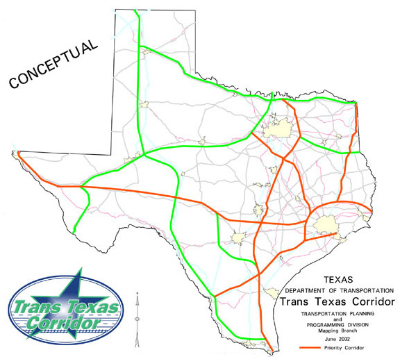
Route/segment analysis The proposed corridor was analyzed with respect to the following criteria:
Rerouting hazardous materials to avoid urban areas. Corridors most likely to generate toll revenue. Opportunities for economic development. Analysis led to the identification of four priority corridors. (Figure 4, see larger map on page 79). Those corridors parallel:
I-69 (proposed) from Texarkana to Houston to Laredo. I-45 from Dallas-Fort Worth to Houston. I-10 from El Paso to Orange. Some 6.2 million Texans live near the proposed corridors. Of those, 59 percent—approximately 3.7 million people—live near the four priority corridors. Of all workers adjacent to the proposed corridors, 56 percent are employed near the priority corridors. Finally, the priority corridors account for 49 percent of total Trans Texas Corridor mileage. In addition to TxDOT’s studies, private-sector analysis will identify other corridors for immediate development and future investment. TxDOT or the private sector will develop the other corridors as each segment becomes more necessary. Public involvement Public involvement will be a key to successful planning and development of the corridor. At present, all segments are conceptual and subject to public comment. During the corridor route-selection phase, any needed changes will be identified through a more detailed, project-specific public involvement process. The public will have opportunities to comment early and often in the development process. TxDOT also will develop other means to keep the public informed, including a Web site, newsletter for stakeholders and a speaker’s network.
The Trans Texas Corridor will have a significant positive impact on the state:
It will increase safety by routing hazardous materials away from highly populated areas. It will generate toll revenue to further improve Texas’ transportation system. It will stimulate economic growth.
Looking Down the Road -
Executive Summary -
Action Plan
-
|
This Page Last Updated: Wednesday January 17, 2007