|
Storms and Flooding: November 22-23, 2004 |
|
|
|
Austin Radar A severe thunderstorm stretches from San Antonio to Houston. The white dot in the red band is the location of Rain Creek Farm. This storm was moving from left to right across the radar screen dumping more than a foot of rain on Fayette County. (11.22.04) |
|
|
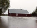
Stall Farm Somewhere under all this moving water is the road, a bridge and a normally slow running creek. Looks like there's about two feet of water in the barn. (11.22.04) |
|
|
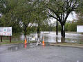
LaGrange The road down to the boat ramp is closed along the Colorado River as the water comes up. Note the light pole out in the middle of the picture. (11.22.04) |
|
|
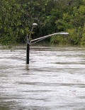
LaGrange The bottom of this light pole is normally high and dry at the boat ramp. (11.22.04) |
|
|
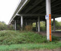
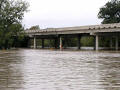
LaGrange The new highway bridge upstream is much higher above the river. Flood water can just be seen in the background of this picture. (11.22.04) |
|
|
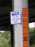
LaGrange The December 1991 high water mark on this bridge was 43.5 feet. (11.22.04) |
|
|
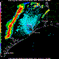
Galveston Radar Another well defined line of very strong thunder storms move across Fayette County. The white dot indicates the location of Rain Creek Farm. (11.22.04) |
|
|
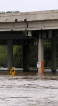
LaGrange Remember the picture where the flood water was just visible in the background? Well this is the same bridge on the new highway a day later. (11.23.04) |
|
|
LaGrange Here is the flood gauge again, this time with the 40-foot mark underwater. (11.23.04) |
|
|
|
|
November 02, 2006 Copyright 2004 David K. Stall | |